
Garmin Releases February 2016 Marine Software Update
In an ongoing effort to improve Garmin products and provide enhanced features to existing users, Garmin just issued its latest marine software update. This free update is available to download now, and provides improved functionality and new features for several echoMAP, echoMAP CHIRP and GPSMAP series devices.
Highlights of the update include:
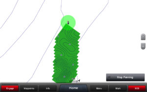
Quickdraw Contours — Improve your existing maps and/or create new maps where none exist with this new software feature.
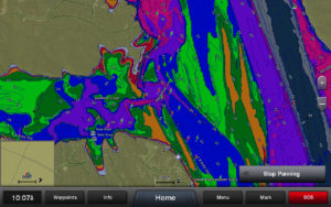
Multiple depth range shading — Chart shading for up to 10 depth ranges using various colors.
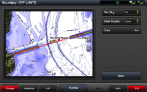
Boundary lines, areas and circles — Create and view boundary lines, areas and circles on the chart page; set alarms when entering/exiting them.
Vertical range radar scaling — Fit selected radar range to the vertical size of your display to show more forward-looking returns on the screen (making it easier to interpret target distances).
Dual range with map overlay — Single radar antenna is capable of providing split screen images on your plotter side-by-side with independent range setting and controls for both close and long-range; one or both ranges can be viewed as a chart overlay.
Commission non-mechanical autopilots without GHC control unit — Supports full autopilot installation and configuration for non-mechanical drive systems.
Additional highlights include support for system profiles and presets; support for Panoptix PS21-TR and PS21-TM transducers; added support for BlueChart g2 HD and BlueChart g2 HD Vision for up to 1-foot contours, and much more.
For more information, please visit: http://www8.garmin.com/support/software/marine.html
