
Garmin® unveils the all-new GPSMAP® 86 marine handheld series
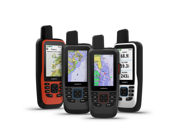
OLATHE, Kan.– Garmin International, Inc., a unit of Garmin Ltd. (NASDAQ:GRMN), recently announced the all-new GPSMAP 86 handheld series, a feature-packed addition to its popular marine handheld collection. Combining Garmin’s premium GPS navigation with inReach® satellite communication technology1, the flagship GPSMAP 86sci is the first handheld to come preloaded with Garmin BlueChart g3 coastal cartography with integrated Navionics data. For added awareness and convenience, the GPSMAP 86 series can connect to onboard Garmin chartplotters and instruments to stream real-time boat data, including depth, heading, sea temperature and more, directly to the handheld. With a sunlight-readable 3-inch color display and water-resistant2, floating design, they even double as a remote control for convenient operation of an onboard Garmin autopilot or select FUSION® marine stereos and speakers.
“Loaded with premium features in an all-new design, the GPSMAP 86 marine handhelds are fully capable of being both a primary navigation device or as an extension and backup to your onboard system,” said Dan Bartel, Garmin vice president of global consumer sales. “With the addition of our industry-leading inReach satellite communication technology and best-in-class marine mapping, no one should leave the dock without one.”
The GPSMAP 86 series offers Garmin inReach two-way messaging and location tracking technology, so no matter how far off shore the trip may be, users can stay in touch. Using the worldwide coverage of the Iridium® satellite network, the GPSMAP 86sci and GPSMAP 86i allow users to communicate with any cell phone number, email address or other inReach device while using GPS to track and share progress of the journey. If the user enables LiveTrack, friends and family on shore wanting to follow along can view the user’s location. The GPSMAP 86sci and 86i also include a mount for hardwiring on the boat, and wireless unit-to-unit connectivity lets users remotely connect to the GPSMAP to send and receive messages on the chartplotter with the handheld securely mounted in a convenient location.
Mariners can use the GPSMAP 86sci and 86i to trigger an interactive SOS for emergency help from a 24/7 GEOS International Emergency Response Coordination Center. The world leader in emergency response solutions and monitoring, GEOS will alert emergency responders and provide updates to the user’s key contacts, while also continuing to message back and forth with the user, until the situation is resolved.
To access the Iridium network and communicate with a GPSMAP 86sci or 86i device, an active satellite subscription is required. A variety of subscription plans are available for both individuals and groups/fleets, and mariners will appreciate the flexible month-to-month options that can be suspended in the offseason if desired.
Both the GPSMAP 86sci and GPSMAP 86sc come preloaded with BlueChart g3 coastal charts for industry-leading coverage, clarity and detail with integrated Garmin and Navionics data. Detailed contours allow users to see 1-foot contours that provide a more accurate depiction of bottom structure for improved fishing charts and enhanced detail in canals and port plans. Users can also add LakeVü g3 inland maps with coverage for more than 17,000 lakes to select models. The international versions, the GPSMAP 86s and 86i, come preloaded with a worldwide basemap.
It’s easier than ever to stay in touch with a GPSMAP 86 handheld onboard. Each device offers Wi-Fi® connectivity, ANT+® technology and Bluetooth wireless technology for easy wireless updates and connections, including smart notifications when paired with a compatible smartphone. When paired with the free Garmin Explore™ app, users can upload their favorite waypoints, tracks and routes and have access to additional tools and features for trip planning, mapping and data sharing. Additionally, the GPSMAP 86 series features support for the Connect IQ™ app , a no-cost all-in-one store where users can access free apps, widgets and data fields to customize their handheld. Each new GPSMAP handheld comes with an internal, rechargeable lithium battery. Get up to 40 hours of battery life in standard mode and up to 200 hours of battery life in expedition mode with the GPSMAP 86sc and 86s. The GPSMAP 86sci and 86i provides up to 35 hours of battery life in 10-minute tracking mode and up to 200 hours of battery life in expedition mode.
The new GPSMAP 86 marine handheld series is available now with suggested retail prices ranging from $399.99 to $649.99. To learn more, visit www.garmin.com/marine.
Garmin is the world’s leading marine electronics manufacturer3 and was recently named Manufacturer of the Year for the third consecutive year by the NMEA, an honor given to the most recognized marine electronics company for support of products in the field. Garmin’s portfolio includes some of the industry’s most sophisticated chartplotters and touchscreen multifunction displays, sonar technology, high-definition radar, autopilots, high-resolution mapping, sailing instrumentation, audio, entertainment and other products and services that are known for innovation, reliability, and ease-of-use. Other Garmin marine brands include FUSION Entertainment, Navionics—a premier supplier of navigation charts, and EmpirBus™.
For decades, Garmin has pioneered new GPS navigation and wireless devices and applications that are designed for people who live an active lifestyle. Garmin serves five primary business units, including automotive, aviation, fitness, marine, and outdoor recreation. For more information, visit Garmin’s virtual pressroom at garmin.com/newsroom, contact the Media Relations department at 913-397-8200, or follow us at facebook.com/garmin, instagram.com/garmin, twitter.com/garminnews, or youtube.com/garmin.
1 Satellite subscription required.
2 Rated to IPX7 standards.
3 Based on 2018 reported sales.
NOTICE: Some jurisdictions regulate or prohibit the use of satellite communications devices. It is the responsibility of the user to know and follow all applicable laws in the jurisdictions where the device is intended to be used.
About Garmin International, Inc.:
Garmin International, Inc. is a subsidiary of Garmin Ltd. (Nasdaq: GRMN). Garmin Ltd. is incorporated in Switzerland, and its principal subsidiaries are located in the United States, Taiwan and the United Kingdom. Garmin, BlueChart, GPSMAP, inReach, and FUSION are registered trademarks and Garmin Explore and Connect IQ are trademarks of Garmin Ltd. or its subsidiaries.
The Bluetooth word mark and logos are registered trademarks owned by Bluetooth SIG, Inc. and any use of such marks by Garmin is under license. Wi-Fi is a registered trademark of the Wi-Fi Alliance. All other brands, product names, company names, trademarks and service marks are the properties of their respective owners. All rights reserved.
Notice on Forward-Looking Statements:
This release includes forward-looking statements regarding Garmin Ltd. and its business. Such statements are based on management’s current expectations. The forward-looking events and circumstances discussed in this release may not occur and actual results could differ materially as a result of known and unknown risk factors and uncertainties affecting Garmin, including, but not limited to, the risk factors listed in the Annual Report on Form 10-K for the year ended December 29, 2018, filed by Garmin with the Securities and Exchange Commission (Commission file number 0-31983). A copy of such Form 10-K is available at http://www.garmin.com/aboutGarmin/invRelations/finReports.html. No forward-looking statement can be guaranteed. Forward-looking statements speak only as of the date on which they are made and Garmin undertakes no obligation to publicly update or revise any forward-looking statement, whether as a result of new information, future events, or otherwise.


